Following consultation with federal, state, and local partners, the mandatory evacuation zone has been reduced from a one-mile radius to the roads and area closest to the incident site.
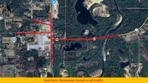
Road Closures Still in Effect:
- LA Hwy 10– From U.S. Hwy 51 to E. Russell Town Road
- US Hwy 51– From LA Hwy 1048 to North Street
- LA Hwy 1048– From a U.S. Hwy 51 to Mt. Gillion Church Road
Alternate Routes for Commercial Motor Vehicles:
- LA Hwy 10 West to LA Hwy 1058 North
- LA Hwy 10 East to US Hwy 51 South (Purina Mill)
The public is urged to continue exercising caution in the area due to the ongoing presence of first responders and cleanup crews.